Posts

Showing posts with the label #ICESAT-2

NASA's ICESat-2 Lifts-Off& In-Orbit

Image
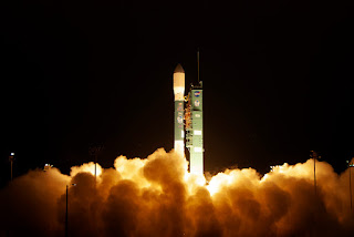
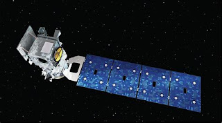
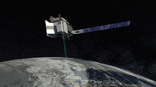
NASA Satellite Will Track Global Ice Melt Photo:  Courtesy of NASA ICESat-2 Global Ice Melt Tracker NASA launched its ICESat-2 satellite into space. The satellite contains NASA's most high powered laser.  It will provide unprecedented, highly valuable observations on how glaciers, ice sheets and sea ice are changing.  It will precisely measure the thickness of Earth's polar ice sheets, snow cover and permafrost. Bonus on Board A surprise bonus is also on board.  2 ELFIN CubeSats.  They're a pair of tiny satellites that will study how energetic electrons make their way from space to the earth's atmosphere. Measuring Ice and Melt ICESat-2's laser splits into 6 beams to precisely measure the Earth's polar ice formations.  The calculations are done by the amount of time it takes the laser beam to leave the satellite, hit and bounce off the ice and arrive back at the satellite. Massive Data & Important Climate Change Insights from this Mission T

NASA Launches Sat Tracking Ice Melt Saturday

Image
Satellite will Provide Vital Information on Climate Change's Impact Image of NASA's ICESat-2 ICESat-2 NASA will launch its ICESat-2 satellite that will track the Earth's melting poles and disappearing sea ice on Saturday Sept. 15.  It will document how ice sheets, glaciers and sea ice are changing. And the information will help to generate new insights into how the changes are impacting people, animals and the environment.  The data also will be used to forecast conditions going forward. NASA's Most Advanced Laser ICESat-2 is NASA's most advanced laser instrument. It measures the height of glaciers and sea ice by precisely timing how long it takes individual photons to leave the satellite, bounce off the earth and return to the sat.  The laser beam splits into 6 beams to cover more ground.  The mission will last for 3 years.

NASA to Track Earth's Ice Melt

Image
Satellite with Most Advanced Laser Altimeter to Track Global Ice Melt ICESAT-2 In mid-September, NASA will launch ICESAT-2.  It's a $1 billion satellite loaded with the most advanced laser system NASA has ever launched into space.  The purpose is to track and precisely document how the earth's ice sheets, sea ice and glaciers are melting.  NASA officials think more than 2/3rds of the earth's ice has melted since the 1980's. Ice Mission ICESAT-2 is going to provide an unprecedented level of detail and precision on how ice sheets' heights and thickness are changing. It's a 3 year mission and the highly advanced laser onboard adds the 3rd dimension to the measuring.  The system is so precise it can document increases and decreases in ice thickness as small as 1/5 of an inch. "Revolutionary" Technology NASA says this instrument is "revolutionary" to study both land and sea ice.  The laser beam splits into 6 beams and fires 10,00