Posts

Aviation Innovation History Just Made in Texas

Image
Lift Aircraft's Manned Drone Multicopter Just Flew Over Texas.  It's all electric and is being called a world first.   https://importantinnovationscollection.blogspot.com/2018/12/manned-multicopter-takes-off.html Source:  Lift Aircraft Photo of Hexa Readying for Takeoff Maryanne Kane

Important Innovations Collection: Manned Multicopter Takes Off

Important Innovations Collection: Manned Multicopter Takes Off : Drone Innovation Took Flight Today in Texas Source:  Lift Aircraft Photo of Hexa Hexa - the Personal Flight Experience Lift Aircraft,...

Important Innovations Collection: Genetics Behind Active & Sedentary Lifestyles

Important Innovations Collection: Genetics Behind Active & Sedentary Lifestyles : Oxford University Large Population Study Source: Photo of Boston Marathon Causes & Consequences of Physical Inactivity New rese...

Climate Change & Great Barrier Reef Update

Image
New Findings:  Less Bleaching in 2017 But Uncertain Fate for Great Barrier Reef Source:  Australia - Great Barrier Reef Experts Call for Urgent Action on Greenhouse Gas Emissions to Save Global Coral Reefs Global warming continues to escalate and the future of the world's coral reefs remain uncertain.  In fact, experts in Australia and at NOAA are urging immediate action to reduce global greenhouse gas emissions to save coral reefs, including the world's largest, the Great Barrier Reef.  Their request for urgent action is a result of their scientific research findings, released today. ARC & NOAA Scientists The new research findings have just been released by the ARC Centre of Excellence in Coral Reef Studies in Australia and NOAA scientists.  They found that the Great Barrier Reef endured extreme temperatures a little better in 2017 than it did during the two previous years of coral bleaching.  Their findings were published today in Nature Climate Change. Surp

Important Innovations Collection: Jumping Robots - Nature Inspired

Important Innovations Collection: Jumping Robots - Nature Inspired : Learning from Jumping Spiders Source:  University of Manchester - Kim Robotic Innovation This research is being conducted at the Un...

Innovation - Sounding Nature

Image
Biggest Global Sound Map of Sounds from Nature A World Without Noise Pollution, Just the Sound of Nature It's called the Global Collaborative Sound Project.  It's the creation of innovator and composer Stuart Fowkes.  Fowkes has been creating sound maps since 2014 including those of sacred places and protests. Sounding Nature His latest sound map is Sounding Nature. It is the biggest global collection of sounds from nature.  It features 500 nature sounds from 55 countries.  It allows you to hear what the world sounds like without humans and without noise pollution.  Fowkes says he's remixing sounds from the natural world with artistic reactions including music the natural sounds have inspired.  For more stories on innovations, go to  amazon.com/author/ekane

Important Innovations Collection: DARPA's Breakthrough for Depression Treatment

Important Innovations Collection: DARPA's Breakthrough for Depression Treatment : Triple Discoveries Including Innovative Treatment  Source:  DARPA Brain Mapping of Neural Activity Could "Radically Improve Trea...

China & Far Side of the Moon

Image
Lunar Mission Chang 4 Source:  China National Space Administration Historic Lunar Exploration This is a global first in space.  China has blasted off a rocket, carrying a rover probe, headed for a soft landing on the far side of the moon.  Other spacecraft have examined the far side of the moon from afar.  But this will be the first soft landing for detailed study of the other side of the moon. January Touchdown The mission - Chang 4 - is expected to land on the moon in early January.  There are some big challenges.  For instance, the moon blocks direct communication between the probe and Chinese researchers on earth.  To get around that, China launched a satellite in May that keeps the probe in contact with the China National Space Administration. Goals Chang 4' rover is going to survey the lunar terrain, determine mineral composition and study the lunar environment.  If the mission is a success, China plans to launch Chang 5 to collect samples of the moon's surf

Laser Shooting Dune Buggy for US Military

Image
Laser Innovation for the US Military Source:  Raytheon HELWS MRZR Raytheon's Laser Shooting ATV It's a powerful laser on a dune buggy for the US Military.  Raytheon's HELWS MRZR laser-shooting dune buggy, all terrain vehicle. Once the human operator confirms the target, a fiber optic electric laser fires a controlled beam that instantly destroys the target. Battery or Electric Powered A simple battery charge enables 30 blasts.  If there's an electrical hookup, the magazine can last indefinitely.  This laser weapon developed by Raytheon for the US military has been cited as one of the most important innovations of 2018.  Raytheon has mounted the laser on a Polaris ATV.  For more laser and other energy news, go to my colleague Ed Kane's Amazon Author Page  amazon.com/author/ekane

Make Way for Drones Not Under the Radar

Image
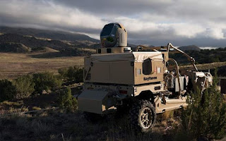
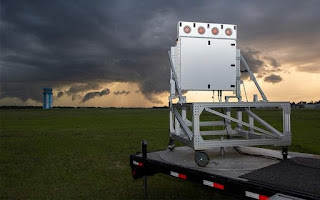
New, Low Altitude Radar Innovation Capable of Tracking Widespread Drone Use Source:  Raytheon Skylar Rollout of Widespread Drone Deliveries Enabled Raytheon Corporation, the US defense contractor, has developed a low altitude, radar system capable of tracking flying vehicles below 3200 feet. It's an innovation breakthrough for the drone aviation industry.  For drones to be able to deliver on their potential, we have to be able to track the small, low flying vehicles, 24/7. Enter Raytheon's Skylar Raytheon's new, low power radar is known as Skylar.  It's a compact unit that's less than one meter square.  It scans for objects using a radar system similar to that in modern fighter jets. Top Innovation - Potential Use This system has been cited as a top innovation in 2018.  Here's Raytheon vision of how it could be deployed.  Networks of these units on cell towers, hills and on buildings.  They say that would be far cheaper and far more effective for

Airbus's Zephyr Solar Plane - Big News

Image
Record Breaking, Solar Powered Plane with First Launch Base in Australia Source:  Airbus Zephyr   Ready for Takeoff:  Is It a Plane or Satellite? Airbus's Zephyr S HAPS (Solar High Altitude Pseudo Satellite) is a solar plane worth watching.  It has set an all time record by staying aloft for more than 25 days.  The flight was over Arizona in late summer 2018.  It soared to 70,000 feet, which is well above most clouds and aircraft. It now has a site in Wyndham, Western Australia as a flight base to launch into the stratosphere. It will fill a gap to provide persistent, local satellite services. Specs The wing span is 82 feet.  It's a solar powered UAV and weighs only 165 pounds.  The low weight along with a unique power management system help it consume a lot less energy.  Despite the fact that it's solar powered, it keeps its elevation all night.  No other solar-powered plane can do that.  For more stories on new aviation and travel innovation, check out this ama

MIT and Google's Breakthru AI System

Image
Creates Highly Realistic 3D Images Source:  Google showing 2D & 3D images Google & MIT Research Team Researchers at MIT's Computer Science and Artificial Intelligence Lab and Google have created a next generation AI system capable of creating 3D shapes with realistic texture, lighting and reflections. VON It's called VON or Visual Objects Network.  It not only generates images more realistic than most state of the art systems.  It also enables texture and shape editing, viewpoint shifts and other 3 dimensional tweaking. 3D & 2D Most systems focus on generating 2D images, which limits their practical use in many fields.  VON synthesizes 3D shapes and 2D images.  The researchers next step is fine modeling for producing shapes and images at a higher resolution, disentangling texture into lighting and appearance and synthesizing natural scenes.  Their research was just presented and accepted at NeurlPS 2018 in Montreal.

DARPA's Angler: Underwater Robot Wonder

Image
Long Duration & Long Distance Sea Duty Source:  DARPA - The Angler Autonomous with No Need of GPS DARPA, the Pentagon's Advanced Research Projects Agency, is applying robotics developed for space and terrestrial exploring robots to a new undersea robotic system.  It's called The Angler. The Angler DARPA is developing an underwater robotic system that autonomously explores the sea floor.  It wants the robot to be capable of physically manipulating manmade objects that it encounters.  Put simply, it's developing highly advanced underwater robots. Robotic Innovation Some of the robotic innovations that will be incorporated into these sea exploring robots: Highly accurate navigations where's there is no GPS Perception and manipulation strategies to grasp objects Systems that allow the robot to know their location and the health of their own system. Current Limits Currently underwater operations are conducted by tethered, remotely controlled robots