Posts

Showing posts with the label #3D mapping

Important Innovations Collection: Exploring Flooded Caves Without Diving In

Image
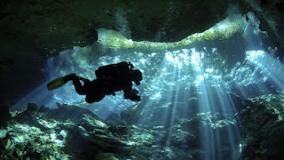
3D Imaging of Flooded Caves New Technology from Czech Company Geo-CZ, a Czech company, has just announced a new technology to 3D Map the space inside flooded, dangerous caves.  It's an important alternative to divers doing numerous missions to inspect the narrow corridors and crevices inside flooded caves.  For a great news blog on this new application of 3D mapping and imaging, go to Important Innovations Collection: Exploring Flooded Caves Without Diving In : 3D Mapping Source: Diver in flooded cave stock image New Technology from Czechoslovakia  Czech speleologists have developed a new tec...

Mapping Subterranean Environments

Image
Pentagon's DARPA on a Mission Stock Image Subterranean Environment For First Responders and Soldiers The US Defense Department's Advanced Research Projects Agency, DARPA, is seeking new commercial technologies to map in 3D underground environments.  The environments include caves, manmade tunnels and other underground structures like subways.  There is a dual need:  for first responders and soldiers. 3D Mapping and Surveying DARPA wants both 3D mapping and surveying.  They just put out a request for information.  There are a number of conditions DARPA wants to overcome in these environments to enable a more safe and rapid response from rescue teams and combat soldiers.  The problems include GPS not working, narrow passages, darkness and dangerous, limited access. Top of the Line Available Commercial Technology DARPA wants highly accurate geolocation data on targeted areas and high resolution georeferenced surveys.  They are particularly interested in top of the l