Posts

Showing posts with the label #satellite

NASA-ESA Sat Monitors Oceans Globally

Image
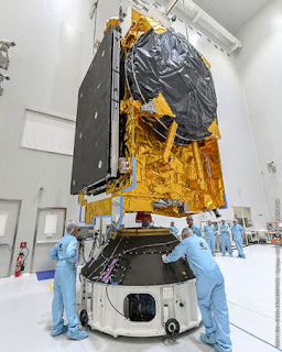
  SAT to Precisely Measure Climate Change Impact on Oceans                                                  Source:  NASA & ESA Keeping a Watchful Eye on Oceans & Climate Change A new NASA and European Space Agency (ESA) satellite to precisely measure rising sea levels from climate change was launched into orbit this weekend onboard a SpaceX Falcon 9 rocket, from California.  The satellite will be able to precisely measures sea levels on 90% of the world's oceans.  This is the latest in a series of ocean monitoring satellites.  But the technologies on this satellite are so precise they will be able to provide sea level measurements within a few centimeters. Weather Forecasting Data Assistance According to NASA, the new satellite will also help improve the accuracy of weather forecasts as it will provide new, in-depth data on humidity levels and atmospheric pressure.  The satellite is named the Sentinel-6 Michael Freilich after NASA former director Michael Freilich who is co

United Arab Emirates Going to Mars

Image
First Arab Nation to Launch Interplanetary Mission Source:  Emirates Mars Probe/University of Colorado UAE To Launch Mars Probe to Document Martian Climate and Atmosphere The United Arab Emirates has big space ambitions and plans.  It is going to launch a mission to Mars in 2020, making it the first Arab nation to launch an interplanetary mission.  The Hope Mars probe will deploy the Hope Satellite to study the climate on Mars. Destination Mars 2021 When the Hope satellite reaches Mars in 2021, it will show how Mars' climate conditions change throughout the year.  The satellite will be launched from Japan in June 2020.  It will reach Mars in February 2021 and collect data for two years.  The mission could be extended through 2025.  Interesting, a female scientists is a key player behind the mission.  Sarah Al Amiri is deputy project manager of the Mars Mission and Chairperson of the UAE Council of Scientists.  90% of the workers on the Emirates Mars Mission a

New Satellite Watching Amazon

Image
China-Brazil Earth Observation Satellite Watching Amazon Rain Forest Source: Satellite Image of Amazon Fires Bi-lateral Cooperation to Help the Environment This is bilateral collaboration on a jointly developed satellite by Brazil and China, an earth observation satellite to monitor the Amazon Rain Forest. The sat was launched today and the Chinese-Brazil satellite development program relationship goes back to 1988.  The recent rainforest fires caused massive damage to the bio-diversity in the Amazon.  The hope is this highly advanced satellite system will monitor, protect and prevent such disasters.  For the Amazon, it seems like a little too late, but it's significant technology that could be very useful going forward for the Amazon and elsewhere globally. Innovation in Bilateral Sat Cooperation BRICS, standing for Brazil. Russia, India, China and South Africa, is the coalition of nations behind forwarding this satellite effort. It's an awesome effort pulling to

Egypt Launches into Space

Image
Egypt To Launch 1st Communications Satellite on Friday Source: Egyptian Space Agency TIBA-1 to Provide Egypt Call and Internet Full Service Egypt is sending its first communications satellite into orbit on Friday.  The government believes this will improve its communications infrastructure and internet services and also attract new investors.  The satellite will work along with existing land and telecommunications infrastructure.  Egypt believes that a strong communications network is essential to its economic growth.  Interestingly, the satellite called TIBA-1's coverage area includes nearby Arab and African nations.  The Egyptian government may sell those areas new satellite services. Launch Date Friday The Friday launch of Egypt's first communications satellite will take place from a space center in French Guiana in one of Europe's Arianespace rockets.  The satellite is 5.6 tons and was made by Airbus and Thales Alenia Space.  It will stay in orbit

Important Innovations Collection: Canada's Quantum Tech to Space

Image
Canada to Launch Quantum Satellite in 2022 Source:  Canadian Space Agency Canada plans to launch in 2022 a new Quantum Satellite that is designed to provide greatly enhanced security to national and commercial communications networks.  The Canadian government believes the new satellite is necessary because in the age of quantum computing, it will be increasingly easy to break through security barriers like passwords, etc. In fact, they think that within the decade current security methods will be totally obsolete.  For a great news blog on this, go to Important Innovations Collection: Canada's Quantum Tech to Space : New Satellite Launch 2022 Source:  Canadian Space Agency Goal:  Protect Communications Networks Canada will launch a new satellite i...

Important Innovations Collection: CubeSats Catch Space Debris

Image
Trash Collector for Space Source:  Rensselaer Polytechnic Institute Tiny, Semi-Autonomous CubeSats Scientists at Rensselaer Polytechnic Institute are developing tiny, inexpensive CubeSats to capture and destroy debris in space.  There are more than 129 million pieces of space debris.  And they pose a danger to space vehicles because they travel at such high velocities.  For a news blog on the satellite system, go to Important Innovations Collection: CubeSats Catch Space Debris : Tiny, Semi-Autonomous, Cheap Source:  Rensselaer Polytechnic Institute New Invention:  Trash Collector for Space Researchers at Re...

Important Innovations Collection: DARPA in Orbit

Image
DARPA Launches Small Experimental Satellite Launch by New Zealand-based Startup Rocket Lab The successful launch and orbit of the DARPA experimental satellite happened today.  The satellite is testing a new platform of radio communications for small spacecraft.  It's called a "membrane reflective-array antenna."  For a great news blog on this, go to Important Innovations Collection: DARPA in Orbit : DARPA's Experimental Satellite Now in Orbit Source:  Rocket Lab's Launch of DARPA Satellite New Zealand's Rocket Lab The...

Airbus's Zephyr Solar Plane - Big News

Image
Record Breaking, Solar Powered Plane with First Launch Base in Australia Source:  Airbus Zephyr   Ready for Takeoff:  Is It a Plane or Satellite? Airbus's Zephyr S HAPS (Solar High Altitude Pseudo Satellite) is a solar plane worth watching.  It has set an all time record by staying aloft for more than 25 days.  The flight was over Arizona in late summer 2018.  It soared to 70,000 feet, which is well above most clouds and aircraft. It now has a site in Wyndham, Western Australia as a flight base to launch into the stratosphere. It will fill a gap to provide persistent, local satellite services. Specs The wing span is 82 feet.  It's a solar powered UAV and weighs only 165 pounds.  The low weight along with a unique power management system help it consume a lot less energy.  Despite the fact that it's solar powered, it keeps its elevation all night.  No other solar-powered plane can do that.  For more stories on new aviation and travel innovation, check out this ama

Smart Ships Remotely Controlled

Image
Captain in California - Huge Cargo Ship Travelling off Scotland Wartsila Autonomous Vessel Remote Controlled Ocean Going Vessels The engineer, his computer and joystick are in California.  5000 miles away, the huge cargo ship that the engineer is piloting is off the coast of Scotland.  The engineer is 100% piloting the vessel with the joystick that's linked to the ship directly by satellite.  He controls the ship by watching the ship - a "virtual ship" on his computer. 4 Hour Experiment This 4 hour experiment was carried out by the Finnish energy and technology firm Wartsila. It worked.  The distance between the captain and the vessel 5000 plus miles. Future of Smarter Ships Wartsila believes the future will feature smart ships.  That will allow ship owners to more efficiently control movements, cut fuel consumption and lower emissions.  Just 15 of the world's largest vessels produce the same amount of sulfur dioxide as all the cars on earth put together