NASA to Track Earth's Ice Melt
Satellite with Most Advanced Laser Altimeter to Track Global Ice Melt
 |
| ICESAT-2 |
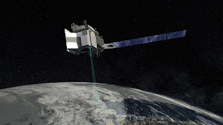
In mid-September, NASA will launch ICESAT-2. It's a $1 billion satellite loaded with the most advanced laser system NASA has ever launched into space. The purpose is to track and precisely document how the earth's ice sheets, sea ice and glaciers are melting. NASA officials think more than 2/3rds of the earth's ice has melted since the 1980's.
Ice Mission
ICESAT-2 is going to provide an unprecedented level of detail and precision on how ice sheets' heights and thickness are changing. It's a 3 year mission and the highly advanced laser onboard adds the 3rd dimension to the measuring. The system is so precise it can document increases and decreases in ice thickness as small as 1/5 of an inch.
"Revolutionary" Technology
NASA says this instrument is "revolutionary" to study both land and sea ice. The laser beam splits into 6 beams and fires 10,000 pulses per second. The system will orbit 300 miles above the earth. The laser beams will bounce off the ice surface and photons will make their way back to the satellite providing data. Everything about this mission is precisely timed to detect measurement changes.
Forecasts on Sea Level and Climate Change
NASA officials believe this detailed study of change in sea ice, ice sheets and glaciers will help forecast the impact of the ice melt on sea levels and climate beyond the poles. In a 1/2 second, it will collect 5000 elevation measurements in each of its 6 beams. That data's coming 24/7 for the next 3 years. ICESAT- 2 has enough fuel to orbit for up to 10 years.
%20(1)%20(1)%20(3)%20(2)%20(2).jpg)


Comments
Post a Comment